
The U.S Department of State has issued an official apology after mislabeling Nigeria and other African countries on the map during a presentation at the 26th International AIDS Conference (AIDS 2026) in Rio de Janeiro, Brazil.
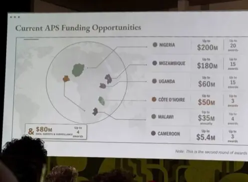
The slide, intended to highlight Washington’s new bilateral health agreements under the President’s Emergency Plan for AIDS Relief (PEPFAR), displayed glaring cartographic errors.
Among the mislabeling mistakes by U.S officials is Nigeria, Africa’s most populous nation and a major West African coastal state, which was depicted as a landlocked country inside the Sahara Desert.
Mozambique was incorrectly positioned as an East African nation, and Côte d’Ivoire was shown in Southern Africa. Uganda and Malawi appeared in approximately the correct locations but with inaccurate borders, while Cameroon had no connecting marker identifying its location. One country was reportedly left unnamed altogether.
Following widespread criticism, the U.S State Department acknowledged the error and issued an apology, accepting full responsibility for the inaccurate presentation.
In a statement, a department spokesperson said the confusion and misrepresentation, particularly involving African partners, resulted from a team member who hastily modified the slide deck shortly before the presentation.
“We take full responsibility for the confusion and misrepresentation, including our African partners”, the spokesperson said, adding that the mistake did not reflect the department’s commitment to its relations across the continent.
Meanwhile, reports emerging revealed that analysis of the presentation found an artificial intelligence watermark indicating that the map had been created using OpenAI tools. The company also said it was investigating the report.
The incident has sparked broader debate over the growing use of artificial intelligence in official government communications and the need for rigorous human oversight.
Emily Bass, an expert consultant for Physicians for Human Rights who attended the conference, said the flawed map symbolised deeper concerns about the current leadership of the Bureau of Global Health Security and Diplomacy and its approach to Africa’s HIV response.
Bass said the incident reflected what she described as a troubling disregard for evidence and historical realities surrounding the continent’s HIV programmes since changes to US foreign aid policies began.
The diplomatic embarrassment has since attracted international attention, with observers warning that official reliance on AI-generated materials without adequate verification could undermine credibility, particularly in engagements with strategic partners across Africa.